|
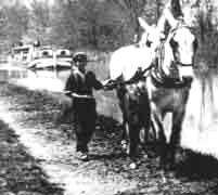
Walking the Feeder Canal Towpath
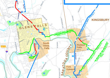
The Glens Falls Feeder Canal trail is a 9 mile
trail suitable for walking from the Feeder Dam in Queensbury to
McIntyre Park in Fort Edward. Directions for starting at Hudson
River Overlook at the Feeder Dam in Queensbury: From I-87, take
exit 18 and go east on Broad Street to Richardson Street (the
first light). Go south .5 miles on Richardson Street from
traffic light at Richardson and Broad Streets.
Reminder: Remain on the trail for your
own safety and in respect for the private property along the
canal. Also, be on alert for traffic at the street
intersections.
Feeder Dam (Parking)
Parking for a few cars is available near the
gates on Richardson Street. Cross the footbridge to the towpath,
making sure to look at the Feeder Dam and the remains of Lock
14, the only Feeder Canal lock in Warren County. Heading east,
the trail includes views of the Hudson River and woodlands.
Haviland Cove and Pruyn's Island
(Parking)
The first bridge crossing the canal is at Bush
Street, which brings the visitors to Haviland's Cove Park, where
restrooms are available in the summer season. The canal and its
towpath form the north boundary for Pruyn's Island. The berm
bank (the side of the canal opposite the towpath) used to be
stacked with drying lumber from the sawmills, awaiting
transportation on the canal. The island was very much involved
in canal life during the 19th century, and many workers lived
here.
Murray Street
Just a couple of blocks before you reach the
Murray Street bridge, you will see a shallow basin across the
canal to your left. This was once the Morgan Dry Dock where
canalboats were repaired. The next section of the trail hugs the
river and approaches Glen Street (Route 9). The Glens Falls
commercial boat basin was just east of the red brick building on
the left.
Glen Street
Notice at the bottom of the falls in the
Hudson river the rock formation known as Cooper's Cave, a site
made famous in James Fenimore Cooper's novel The Last of the
Mohicans. At the Finch Pruyn parking lot, please follow signs
which direct trail users to a 1 mile detour on city streets.
There are two ways to detour around Finch Pruyn. You may either
take a left on Glen street and then take a right, heading east
on Warren Street and follow this past the Hyde Collection to
Shermantown Road. Or, you may take a left on Glen Street and a
quick right onto Oakland Avenue. until it intersects with Warren
Street. Be careful, Oakland Avenue often has heavy traffic on
it. At Warren, take a right, heading east past the Hyde
Collection to Shermantown Road.
Shermantown Road
Take a right on Shermantown Road to return to
the Feeder Canal towpath. After crossing the bridge, turn left,
and continue east along the trail. To your right you will see
the stone work and ruins of a series of lime kilns. At one time
there was more than 83 lime kilns along the Feeder Canal. Jointa
Lime, now behind you, dates back almost to the beginning of the
canal. After a pleasant walk around "the big bend" , you are
approaching Glens Falls Portland Cement which straddles the
canal. The loading dock is still intact under you. As you look
down, you see remains of a huge scale imbedded in the towpath
there.
River Street
When the towpath reaches River Street, it
is important that you cross this busy intersection with the
light. Back on the towpath you pass
the Ciba-Geigy treatment plant, heading for the county line. The
bridge coming up has many names; Quarry Crossing, County Line
Bridge, and Warren Street Bridge.
As you enter Washington County, the canal
crosses Cold Spring Brook via a small stone aqueduct only
visible from the north side. The wooded banks and vines
trailing over the walls are reminiscent of rivers and trails
in the Adirondacks. As you approach the Whitehall Bridge
(route 4) you might decide to stop for an ice cream or a
cold drink at the snack stand. At route 4, you should use
caution when crossing the road. Go to your left and cross at
the traffic light. You will notice that the towpath is now
on the north side of the canal.
Martindale Avenue and the Martindale Boat Basin
(Parking)
You will now come up on the Martindale Bridge
and you will see the Martindale Boat Basin on your right. Stop
and enjoy the wonderful park where there are picnic tables and
park benches for you to enjoy. Continue on the towpath, you will
cross Maple Street and Pearl Street. Just before the Pearl
Street Bridge, you will see lock #13.
Burgoyne Avenue
As you make your way towards Burgoyne Avenue,
you will pass Lock #12 and Lock # 11 (located right before the
Burgoyne Avenue Bridge). The next series of locks (#10-#6), the
Five Combines, can be seen shortly after crossing over Burgoyne
Avenue, where picnic tables are also available for your
enjoyment. As the towpath continues east toward the T-Bridge,
you will pass by the last 5 locks of the Feeder Canal. The the
towpath continues until the T-Bridge, where the Feeder Canal
flows into the Old Champlain Canal.
Old Champlain Canal
Take a right and follow the trail south. About
1 mile down the trail there will be 3 bollards in the road. Pass
through these and continue down the trail past a farm.
Eventually, you will pass Energy Park on your left. The trail
continues a little further until it ends at McIntyre Park where
there are places to park.
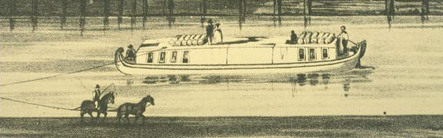
Canoeing the Feeder Canal
The Glens Falls Feeder Canal is suitable for
canoeing for five miles from the beginning of the Canal at
Feeder Dam to the takeout at Boat Basin Park on Martindale
Avenue in Hudson Falls. The water is no more than 4 feet deep.
ACCESS FOR LAUNCHING CANOES
Feeder Dam
A canoe dock is available at the Moore
Memorial Bridge at Feeder Dam in the town of Queensbury. Parking
for a few cars is available near the gates. Canoes can be
carried around the gate through the opening to the dock.
Beginning at Feeder Dam, the canoeist will
paddle under the Bush Street Bridge, past several industries
on Pruyn's Island, and through Finch Pruyn's busy complex.
If the water level is high, it is sometimes necessary to get
low in the canoe to pass under an open structure holding a
pipe across the canal at Finch Pruyn. Of special interest is
the passage through the paper mill's operation. During the
canal's commercial days, Finch Pruyn shipped many loads of
newsprint for New York City before the canal closed in the
1920s. The next item of interest on the canal are the
ghostly chalk white buildings of the Jointa Lime Company. At
one time there were more than 83 lime kilns along the canal.
Shermantown Road
A canoe dock is also available at Shermantown
Road in Glens Falls. Located off Warren Street, cars may be
parked on Shermantown Road. Canoeists should be aware that there
is a four foot drop from the dock to the water at the
Shermantown Road dock. Entering the canal at this point the
paddler will avoid the Finch Pruyn complex and Jointa Lime
Company. After easy paddling around the bend in the canal, Glens
Falls Cement company comes into view. Continuing on, the canoe
first will pass through a tunnel under the highway at Route 254
and continue on past the Samaritan Counseling Center and rural
wooded areas noted by bird watchers. When the bridge at Route 4
is reached, the Martindale Avenue Bridge will be next and it is
time to look to the right for the take out docks at Boat Basin
Park.
Martindale Avenue
A parking lot suitable for a number of cars is
available at Martindale Avenue in Hudson Falls. The end of the
five mile canoe trip includes several docks, park benches, and a
small park. Many boaters leave a second car at Martindale to
avoid the return "upstream" trip to Feeder Dam.
Five Combined Locks
Many bicyclists and walkers enjoy the view
from the top of the Five Combined Locks, Burgoyne Avenue in
Kingsbury. Although the canoeist must take out at Martindale to
avoid the locks, it is a short trip by car for those who want to
see the impressive staircase of locks at Burgoyne Avenue.
Note: The Feeder Canal Canoe trip takes
about 1 1/2 hours of easy paddling with the current if started
at Feeder Dam. It is hard to remove canoes at any point other
than the access points listed without venturing onto private
property. We advise our trail users and canoeists to be
respectful of private ownership.
NEXT |